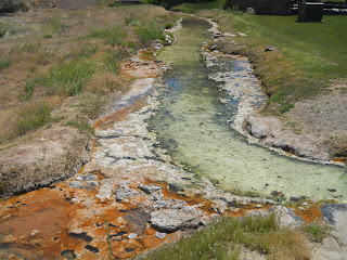
From Cody, I drove to Thermopolis, home to the world's largest hot spring, and spent the afternoon at Hot Spring State Park. The park is known for its colorful terraces (gypsum and lime) and mineral hot springs. The water flows at a rate of 18,000 gallons per day and was once thought to have healing powers. The waters are now maintained at 104 F, which is safe to swim in, compared to the normal 135 F.
This is Teepee Fountain, built in 1909 to vent steam from hot mineral water that was piped throughout the park. As water flows over the structure, it cools and deposits layers of travertine. This process is similar to the formation of terraces seen throughout the park.
Here is a photo of the original. Below is what it looks like now!
I walked down to the river by where the boats were being unloaded off of trucks. You can see more of these "travertines" on the side of the river.
These are rocks by Black Sulfur Springs.
Part of the park is a large gated buffalo pasture. I went through at a slow speed when there were buffalo, but went a little faster in all the areas with no buffalo. Someone in an old pick up truck wasn't pleased and felt the need to yell at me for "lacking respect for the far away buffalo".
Anyways... Here is Spirit Hole. These are ancient travertine terraces formed by mineral springs that once flowed into the Bighorn River.
There were only 5-6 bison that I saw in the pasture, which surprised me, but there are 24 throughout this state park.. The Bighorn Bison had huge herds all along the rivers and grazing the extensive sage and grassland habitat. Indiscriminate slaughter, habitat destruction and fragmentation almost drove these bison to extinction. By the end of the 19th century, there were fewer than 500 bison, and most were in Yellowstone. Extensive conservation efforts saved them. Today there are over 270,000 in protected and private lands.
Here is Joe Sneider Point. In 1884, Sneider passed through this area, noticed steam rising from the hot springs. He thought it was smoke and suspected a hostile Indian camp. The area was scouted from this point before descending to the valley.
This is the Smokey Row Cemetery. During the late 1800s difficult travel and lack of housing did not discourage people from visiting the springs. Upon their arrival, some people pitched tents, while others cut temporary dugouts into the hillside. Travelers entering the valley saw the smoke from the numerous wood stones and named this area "Smokey Row".
This was interesting - an odd place for a big pile of junk metal
This area is called White Sulfur Springs.
The original swinging bridge was built in 1916 to connect the Big Spring with the Fremont Spring, the Pleasant View Hotel and Sanitarium, and the Elk Pasture. The original bridge was condemned in 1984, removed in 1991, and restored in 1992.
The bridge is on a path through the hot springs and terraces.
Here are the hot springs.
I left the park and went down Hwy 20. The river and cliffs on side of the windy road made this a spectacular drive!
This black granite stone off the side of the road in the cliffs is pre-cambrian and over 600 million years old!
This is the site of the original Boysen Dam. Mule teams hauled the materials for the original dam, built in the early 1900s to provide power for Boysen's gold and copper mining interests. A few years later, rising water behind the dam was declared to be a menace to the new Burlington Railroad operation, which went through the Wind River Canyon. Boysen was sued and ordered to remove the dam. Another dam further upstream replaced the original dam.
You can see the new dam and reservoir below, which was built in 1951.
500 yards northwest of these cabins stood the Bonneville Cabins, built in 1835 by Bonneville to store his trade goods. Three cabins were constructed, and later, two more. They were known as "The Five Cabins" In 1866 Major Baldwin moved a stock of goods into the cabins to trade with Shoshone Indians, but vacated the following year due to Indian hostilities.
I now have moved past the Wind River Canyon and into the Red Canyon, which you can see below. This rock is gorgeous!
Although I don't enjoy driving down long hilly dirt and gravel pothole filled roads, I decided to go through one more mining ghost town. :-) (I'm blaming Ralphie for this as he get me hooked at Bodie. LOL)
This is my last one - South Pass City. South Pass is a region rich in history and a city rich in gold. From 1812 - 1868 this open country at the end of the Wind River Mountains provided a passage through the Rock Mountain barrier of the Continental Divide for 500,000 Americans heading west. Through the Great South Pass came the mountain men, fur trappers, explorers, missionaries, military expeditions, and Pony Express riders.
By 1866, traffic on the great trails dwindled with the anticipation of the transcontinental railroad. In 1867, gold was discovered in Willow Creek and the gold rush was on. By 1869, there were more than 30 mines and 3000 people populated in the region. South Pass City, Atlantic City, and Miners Delight became instant cities open for business.
The Female Suffrage Act was introduced by Bright to give women in WY the right to vote and hold public office. It was signed into law in 1869, making WY the first in the country to grand equal rights to women. This was done in WY because the male dominated mining district needed to be more appealing to women.
In the 1870's, the mining went bust and the population moved to the next popular mining area. As with many of them, the towns became near ghost towns, and today, South Pass City is a historical site.
One of the things I like about this ghost town is the focus on mining compared to just the town buildings. You can see into the mine, as well as the tools and equipment they used.
This was an interesting overlook spot. With South Pass behind them, OR and CA bound travelers faced the second 1/2 of their journey - the roughest travel was yet to come. From Missouri to South Pass, travelers could follow rivers, but now (as you can see) there are long dry stretches of high altitude desert. The dry climate played havoc with wagon wheels kept shrinking wood from the iron rims.
Riding day and night (regardless of weather) on the fastest horses available, Pony Express riders maintained a vital communication link between east and west at the beginning of the Civil War.
The completion of the transcontinental telegraph line in 1861 marked the end of the Pony Express.
"...This morn we arrived at the South Pass after which all water we see will be running to the Pacific. So we are now on the other side of the world..." - unknown
A great exodus to the Salt Lake Valley in 1847 was only the beginning of Mormon emigrant travel along the Oregon Trail. 68,000 took the UT branch of the trail from 1847-1869 due to the completion of the UP Railroad. For a brief 18 months beginning in April 1860, 80 young men carried the nation's mail on horseback for 1600 miles from MO to CA.
I was sad to see a ranch that had several hundred wild horses caged in a fence. I always admire them for their freedom and it's silly to call caged horses "wild". :-(
This picture is of true wild horses. The others (as you can see) are caged...
I had never seen (or even heard of) the Flaming Gorge. This wasn't on my initial itinerary, but decided to drive the scenic road, ending up pretty close to Grand Junction, CO again!! :-)
Major Powell named the Flaming Gorge, and nearby areas (like Little Firehole Canyon) for the brilliant red sandstones exposed in the canyon walls. Embarking from Green River in river dory boats, Powell completed 2 voyages down the Green and Colorado Rivers to the Grand Canyon in 1869 and 1870. He collected data and created maps.
Rocks in this area are young (about 49 million yrs old). Continuing downstream toward Flaming Gorge Dam and going down the tributary canyons (like Little Firehole), show older rock formations with dinosaur fossils.
The Green River through Flaming Gorge is a classic example of a superposed stream - it flows across the eastern end of the Uinta Mountains (rather than draining away from the mountains.
This is the Flaming gorge Dam. The dark red sandstones and shales near here of the pre-Cambrian Uinta core form the near vertical canyon walls. These rocks are 1.1 billion years old!
The dam is 455 ft above the river and extends below the river another 47 ft, anchored in bedrock. 1 million cubic yards of concrete were used to make both the dam and power plant.
The sun was setting as I drove along the Flaming Gorge. I contemplated stopping for the night and continuing on in the morning, but I enjoyed the colors of the sunset too much to stop. :-)
These are scenic views of the Vernal and Ashley Valleys in UT.


