
The Grand Canyon rim to rim hike has been on my bucket list, and this spring seemed like the perfect time to cross it off the list. It seemed like a sign that the Ford GT's 2nd annual Getaway Cruise would also be that weekend. Perfect timing! :-)
Two weeks before my hike, I re-injured my right knee during the last 10 miles of a long bike ride, making me rethink the hike. Then the week before leaving I learned that I still needed another 7 iron infusions to get my H&H levels up as the first 3 didn't seem to do too much. (Those of you who hike with me know what lack of O2 to the brain does to me. LOL) Again, I briefly considered postponing this hike until my levels were higher, but my excitement to accomplish this was too great.
After looking at temperatures that week at the bottom of the Grand Canyon and seeing that they were already creeping into triple digits, I decided I would hike from the South to the North Rim. There is an extra 1400 feet or so of elevation to climb this way, but I figured that less initial downhill would be better for my knee and I planned to be hiking up in higher elevations by the time the sun was at its peak and avoid the scorching heat at the bottom of the canyon.
My friend Ralphie would be picking me up from the other end in his beautiful red Ford GT - incentive to push me on and complete the hike when climbing the final pitch. :-) The hike is 24 miles, has about 4500 feet to hike down at the beginning, a "summit" of 2400 feet, and then the last 14 miles (when my body is tired) I'd be climbing 6000 ft out of the canyon - the opposite of climbing a mountain.
On Thursday after work, I drove to Cameron to enjoy a nice dinner at the trading post, and then reached the South Rim in time to take a few pictures at sunset.


I drove to the Grand Canyon Village, bought a banana, OJ, and a bagel for breakfast, and found a "rim to rim" t-shirt. I walked around for a little bit and then drove back to the Visitor's Center. It was already dark, so I used the light in the car to set up the blankets and get ready for bed. My alarm was set for 2:30 AM. Just a few hours to go!!!
That was a LONG night! My legs are far too long to fit in the car, so despite actually being nice and warm, I was not really able to fall asleep. By the time my alarm went off, I was worried about how the hike would go with only a couple hours of sleep over the past 2 nights. I called the cab, put on my knee and ankle braces, and was at the trailhead with my headlamp ready to start by 2:45 AM.
The weather at the top of the South Rim was in the upper 30's or low 40's with a 20 mph breeze, making it quite chilly! (Hard to imagine that in just 2 hours I would be in 85 degree weather.) I paid the cab, turned on the headlamp, and headed down the trail with my trail running shoes and backpack. I usually hike downhill fast, and this wasn't an exception. However, without being able to see the dropoffs and trying not to sprain an ankle on the rocks, gravel, and logs, I had to slow my pace a little bit.
Cedar Ridge was my first landmark at 1 1/2 miles into the canyon. I couldn't see anything due to the dark and it took a minute to figure out where the trail continued. I had been down the South Kaibab trail before during daylight hours, but it's much different (and kind of spooky) in the dark!

After another 1 1/2 miles of hiking down into the canyon, I reached Skeleton Point. It was still dark and I was making great time. The trail was easy to follow, but a bit rocky with small loose rocks and gravel, larger rocks protruding out of the trail, and logs placed at odd intervals, making it hard to hike without sliding or tripping. I really had to pay attention to the trail.

A little further down I came to Tip-Off - my third landmark. Only 4 miles or so to go until reaching Phantom Ranch!

This was a little critter I saw along the way. It was about 3 inches long and looked like a mix between a centipede and caterpillar. These little guys and black beetles were about the only things accompanying me on the way down. :)

Finally! I could hear the water rushing below me somewhere in the dark, and knew I was at the CO River - the lowest point! I would follow the River Trail for a short bit until it came to the North Kaibab Trail.

The camera didn't take great pictures at night, but there were a number of cacti that were just beginning to bud (and would probably be in bloom next weekend), and these little white flowers made me smile as they brightened up the dark on the trail.

The downhill part was now behind me. There were a few ungraceful moments where I almost rolled the ankle despite looking down at the trail, but overall, I made it down to the CO River by about 4:45 AM. I looked back every now and again and noticed there were a few headlamps behind me (which I would soon find out was a good looking group of 4 guys who were running rim-to-rim-to-rim - CRAZY!). Other than that, the first 8 miles were just me and the dark. I wish I had known they were back there and I would have joined them!!
At the river by the bridge was a sign for Phantom Ranch (where I was headed) and one for the S Kaibab Trail (going a different way that I had just come from). I guess it continued on for those who wanted to take it, but it seemed a little odd to me and I was second guessing myself on whether or not I somehow ended up walking from South Kaibab to the Bright Angel Trail, but that wasn't the case. (Navigational skills are not my forte. Yes, that's quite an understatement for those of you who hike with me regularly...)

This is the bridge crossing the CO River. I tried to take a picture of the river as it was roaring loudly under me, but they just turned out black.

Sadly, there would be no condors, rattlesnakes, scorpions, or mountain lions to see on this trip, but I did run into (quite literally) a few mule deer curious and brave enough to rub against me. There were also a lot of bats down by the Bright Angel campground, which looked amazing against the night sky!!

Bright Angel Camp Ground had water, but since I had only used a little bit of my water at this point, I chose not to hike down there and fill up. Since Phantom Ranch doesn't open until 8 AM, there wouldn't be water for another 7 miles, meaning I'd have to hike through the box - the hottest 5 miles of the canyon - with the water I still had left. I probably should have stopped here to fuel up (eat), drink, and refill the water, but instead, just headed toward Phantom Ranch...

Just about there, I saw horses near the lights I had made out from the hike down.

It was about 5 AM and I stopped at a picnic table near the cabins at Phantom Ranch where others were waking up, and ate a power bar and had some Gatorade. Another lesson learned... Don't pack all dry food. It was already in the 80's down there and the sun hadn't even started to come out. It was hard to swallow the dry food, even with the water, so I only ended up eating 3/4 of the bar. I was now down to just over 1 L of water after the short meal, but didn't want to back track to fill up and thought I'd have no trouble making it to Cottonwood Campground. (In this case, I was right. However, had this been the hot part of the day, I wouldn't have made it on that!)

I did not see the summit marker (probably because it was dark), which I think is somewhere near the CO River and bridge, but I did see this marker by Phantom Ranch indicating the trans canyon telephone line was a historic landmark. The poles could be seen throughout the hike.

When I left Phantom Ranch, the sun was coming up and I could put away the headlamp. I took out my floppy hat and sunglasses, and put on the sunscreen in preparation. I also spent a lot of time trying to take off the knee braces (which were sticky and sweaty), and then switched knees as they were starting to rub uncomfortably. This time, I put them on over the hiking pants, even though they didn't look very fashionable. (This proved to be a great move as they caused no sores or blisters, and were very easy to remove after the hike.)

There would be no water or toilet stops for about 6 1/2 miles. My next destination was Cottonwood Campground.


You can see the sun coming up. The next 5 miles from Phantom Ranch are what is known as "the wall". It's the narrow part of the canyon, where tall slabs of black and brown rock greet you from both sides. The trail follows the creek through the inner gorge, providing a nice place to soak my clothes every once in a while. (Unfortunately, I also lost my floppy hat in the creek during one such soaking.) There was some cloud coverage, so even though this part of the hike could on some days get up to 140-150 degrees (heat is absorbed by the black rock walls), it was probably under 90 and comfy warm the entire time. :-)


This is one of the flowering cacti that I saw along the way. There were some purple ones as well.


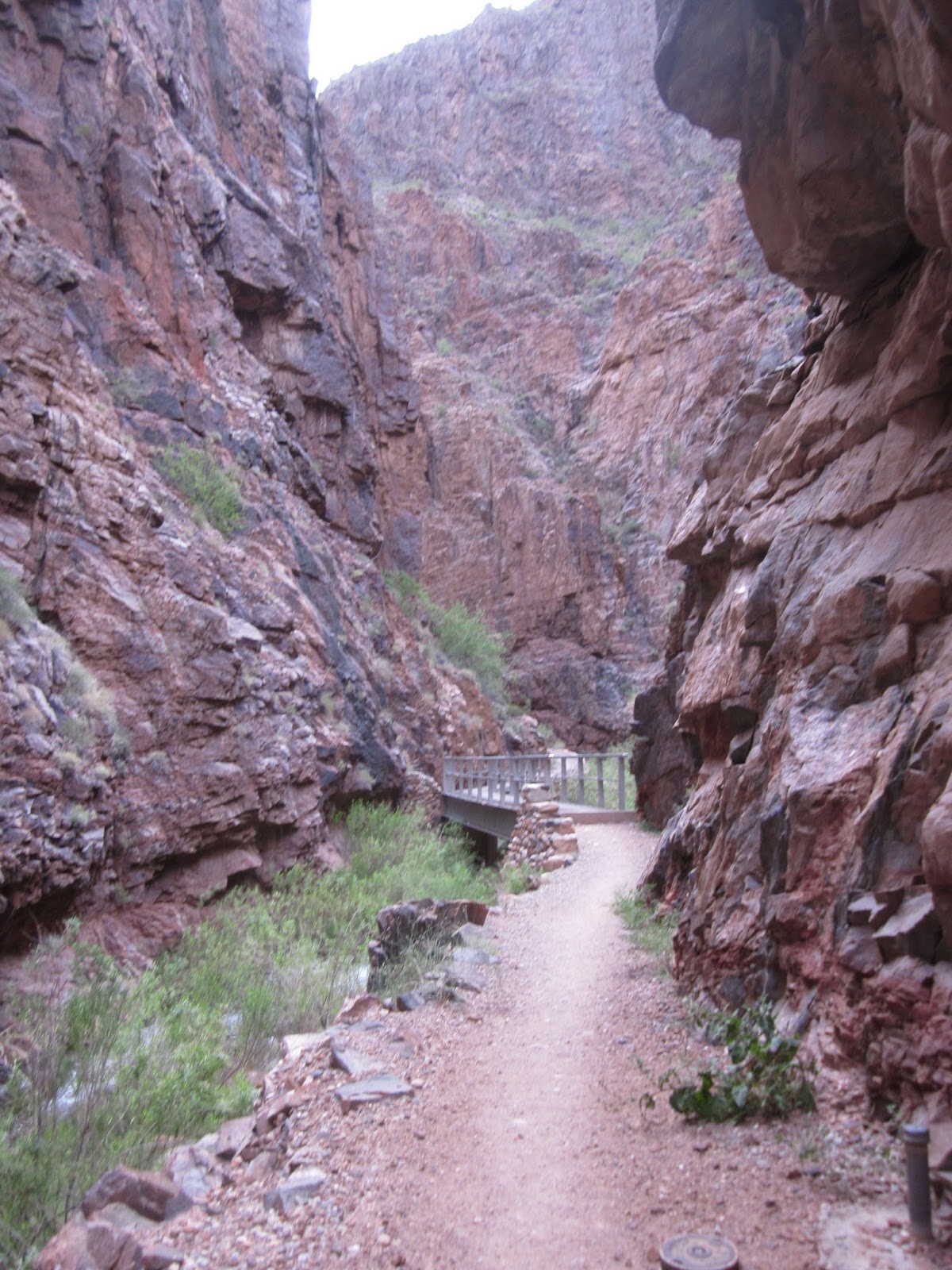
This is one of 5 bridges that crossed over the creek during the "wall" hike. Counting them helped know how much further it was until the wall section opened up a bit. It was also one of the more beautiful parts of the hike to me.
The cute trail runners were still behind me, but catching up. I was still hiking fast through the wall. During this time, there was only one person (another runner) who I passed coming from the other direction. Another early bird like me. :-)

With the sun up, the bottom of the Grand Canyon was amazing! I didn't realize how much life was down there. This green swampy stretch is an example of something that doesn't seem likely to survive the desert heat in the canyon.

This is a look back at the South Rim.

At this point, I could go left to Ribbon Falls or climb up a hill on the right (where the sign says Ribbon Falls via Bridge). The sign is very poor here. It should have said "Ribbon Falls loop" with an arrow pointing to the left, and "North Kaibab Trail" with an arrow pointing to the right. What happened is I thought I'd bypass Ribbon Falls to save time and took the right turn. That was a mistake. I ended up climbing 300+ feet just to climb back down again. The end of the Ribbon Falls loop (which was only about 1/4 mile in and 1/4 mile out with no elevation change) was the bridge that I got to at the bottom. However, if I wanted to see Ribbon Falls from there, I'd have to back track. I know you are just thinking I have navigational issues (and you'd be correct). However, many people I talked to on this trail have done the same thing...

Here's what Ribbon Falls looked like. Sometimes this is a heavier waterfall, and the trail can even be flooded. Would have been nice to cool off under it, even though it's a bit thin right now due to drought conditions.

Here is a closeup. You can see the moss above and underneath it. After spending a lot of time at Yosemite last year I saw quite a few impressive waterfalls - and this is not one of them. However, because it's in a spot where you would not expect to see a waterfall (or moss), it makes it unique and one of the Grand Canyon's treasures.


This is where I met Mark and his running partner for the first time. My first thought about Mark was how cute the guy in blue was with his shades on and killer legs. (Yes, I have a thing for nicely toned legs...) We said hi and I learned he was doing the rim-to-rim-to-rim run/hike. I hadn't known he was the one I saw w/the headlamp close behind me from the start (his group started 15 minutes after me). Now I wish I hadn't gone quite so fast from the start!!

This was a very cool rock formation visible just past Ribbon Falls.

And finally, I arrived at Cottonwood Campground. Despite sipping water every 15 minutes or so, I had only drank a total of about 1 1/2 L of water and now finished about 16 miles of the hike. I used this as a rest spot to drink another 1/2 L of water and eat some trail mix. The dry food was still not going down well.

Guess who was taking a water/food break as well? The trail runners! I talked with Mark a little bit more and learned that 3 of the guys from his group (including him) were from Washington DC and the 4th guy was from San Francisco. One guy's name was Steel. Interesting! This was their 2nd attempt at the rim to rim to rim (the first was cut short by a snow storm in April last year when they did it). Mark and his friend were going to wait a few minutes for the other 2. I was ready to go and said good-bye, wondering when his group would pass me again.

From here, the trail started switchbacking and was significantly steeper, though it was never terribly steep like the mountain trails sometimes get. My knees were doing okay thanks to the braces and Advil, though I still had pain with each step. On the uphill climb, I noticed that the overcompensating to save the knees used my other leg muscles more, but it wouldn't be an issue until I had only about 2 miles left. I still felt strong at this point, though it's the last time that I would be ahead of Mark and the guys...


This was a small waterfall I saw along the way.

Sure enough, only a couple miles later these 2 knuckleheads caught up with me. Always a good thing to make friends on the trail. :-)

I was wishing I had eaten more as I was starting to run out of energy, but still kept moving despite the slower pace. It wasn't like I didn't have food. In fact, I would have loved to lighten my load by eating more, but I was finding it very difficult to swallow the dry food. I was envious of my new friends as they had all soft food that looked so good!!!

A look to the north reminded me the easy part was done and it was time to climb up, up, and away! :)

Here is roaring springs. You can hike down about 400' to get a better look and fill up on fresh water, but with the long climb ahead, I was content to enjoy it from afar.


A look behind at what I'd already climbed.


The north rim scenery was absolutely gorgeous!!! I stopped at least a dozen or more times to enjoy the view and take pictures.
There are a number of different types of rocks you pass as you climb up through the canyon, and the park service did a nice job of posting several signs along the trail letting us hikers know what we're looking at. My favorite was going through the reddish brown rock and finally reaching the white rock near the top! :-) If you look at the canyon in the picture below, you can see the white part near the top that I'm referring to. The forest is just above that.

And in this picture (see below), you can see at least 5-6 different types of rock - all of which help determine the age of the Grand Canyon.
You can also see the trail cut into the rock about 1/2 way down in this picture. This was the best part (albeit the most tiring) of the hike.

I wonder what it would be like to rappel down from this rock? Hmmm...

This bridge is one of the final landmarks. Unfortunately, you have to drop down a few hundred feet to cross it, only to climb right back up again...

If you look hard enough, you can see the bridge from the last picture. I wasn't moving fast, but was making good time. It didn't feel like I had climbed more than a couple hundred feet and was pleasantly surprised!

My first thought when I saw this helicopter was... search and rescue! :-( I hoped nothing bad happened, but my mind was racing. Then as it got closer, I saw the tourists inside and realized it was just a helicopter tour ride. Whew!

Another look at the helicopter as it flew back up. Note how close I am to the top of that ledge!!! Yippee!! :-)

This is the Supai tunnel. I stopped inside the tunnel where there was shade and had a power gel. I didn't realize my hiking buddies were resting just on the other side of the tunnel!! What a pleasant surprise it was to see them again! :-) Unfortunately, by the time I came out, they were getting ready to leave and I still had to use the toilet, eat, and fill up with water, so we talked for a little bit and then said good-bye...
There was another guy I met here who said I looked tired. (I thought I looked pretty good!) I told him I'd been hiking since 3 AM and came from the South Rim. He seemed rather impressed by that and thought I had just hiked down to there from the north rim. Before leaving, I dumped a liter of water over my head and clothes with the cold water, which made me smile. It felt amazing! Only 2 miles left and 1400 feet to climb. Almost there!!
The rough part of this final stretch was all the sand. It was a few inches thick and I would sink into it with every step, exerting a lot of extra energy.

The next (and last) stop before the top was Cononino Overlook - about 400 feet from the top. It was cool and breezy up here - a wonderful switch from the heat generated from the desert air and climbing up for so long. (To be honest, this was one of the cooler days to be hiking!) At this point, I half expected to see Mark and his group running back down and passing me on the way to the other side. I felt like I had been going no faster than a crawl, but it was only 10:30 AM!

View from the top. Other than knee and calf pain, I felt great! (Or maybe it was seeing Mark and the others up there, who waited for me while resting and were all smiling and clapping when they saw me.) I felt silly as they had not only beat me up, but all looked fresh and ready to start hiking back down to do it all over again!!!!! They included me in their group photo and invited me to run and hike with them to the other rim. If only I thought my body could have made it... :-)

Since it was only 11 AM (and I had told Ralphie I'd be ready about 2:30 PM), I needed to go up the road to find a place that either had cell service or go to the Lodge or Visitor Center. I took off my ankle and knee braces, fueled up with food and water, and then said good-bye and wished the boys a safe journey back to the south rim.
And look what I found when I got to the Visitor Center!!! :-) It didn't take long to track down Ralphie, and we shared a nice lunch together before heading back to the South Rim to get my car. A great end to an even better day! (And it wasn't even noon yet!!!!) :-)

The hike took 8 hrs and 15 min, which included all the rest and food breaks, and wasn't anywhere near as difficult as I had thought it would be. Maybe next year I'll do it again from the other side...
And here are a few pix from the Ford GT Getaway Cruise in AZ that followed the hike. :-)


My new GT40.

My car wanted to join the group the last day and enjoyed the company of its favorite 2 GTs. :-)


Feeding the burros in Oatman off of Route 66.


