

We had chips with 4 different sauces (I stayed away from the spicy ones) and verde rice with our meals, which was excellent!! Someone was celebrating a birthday at the table next to us, so desserts with sparklers were given. :) The rest of us had green cotton candy for dessert. Lots of sugar was just what I needed to get me to Rhode Island without falling asleep on the road. And what would a restaurant be without sporting their logo on your arm? LOL


We left the restaurant and went down Greenwich's car strip, where they were building a McLaren store! (Only in Greenwich.)

The drive to Rhode Island was not fun, but I stayed awake and made it to my sister's place before midnight (to avoid turning into a pumpkin). LOL
The next morning as my sister Jean left for work, I left for Cape Cod. There wasn't much going on as it's not tourist season up here, but that also meant no problem driving around. I started out with a short 2-3 mile jog in Harwich by Brewster to warm up and enjoy the crisp cold air and woody scenery.


From there, I drove toward 6A and passed by Bill's Bog. I had to stop by! It's a cranberry bog. In the summer months, you'd see cranberry's in the water. This time of year (a testament of how cold it was) the cranberry bog was full of ice crystals.


I took 6A up the East coast and passed by lots of small villages with little shops (mostly closed), old gas stations, and lots of trees. The atmosphere was quiet and calm. Quite a switch from what I was used to!


I then went to each of the lighthouses in Cape Cod. The first was Nauset Light.


Walking back from the beach, the winds were so strong that they kicked up a lot of sand and created a small sand storm. Not fun with contacts!

Just up the way from this lighthouse were 3 older lighthouses called "Three Sisters Lighthouses". These used to overlook the Atlantic Ocean and provided a landmark for sailors in the late 1800's to early 1900's. The cliffs started to erode and technology improved, so these were then moved and replaced by the lighthouse in red.

Marconi Station Site is not a lighthouse, but was still my next stop. Cape Cod looks like an elbow and a fist (or someone trying unsuccessfully to make a muscle). Marconi (which makes me think of macaroni and cheese) is half way up the arm between the elbow and the fist, and is on the narrowest part of Cape Cod. Unfortunately, Cape Cod is slowly eroding into the ocean.


Marconi was named after an Italian. :) In 1890 he transmitted wireless telegraph signals using only tin plates (and he was 1/2 my age)! By 1899, he was able to transmit signals 20 miles, and by 1903 he sent a message to England!!

Highland Light (also known as the Cape Cod Light) was the next lighthouse on the route. The lighthouse had to be moved back due to erosion of the cliffs. Basically in the winter time, the waves crash against the bottom 1/2 of the cliffs, wearing it down, but the top stays where it is as the clay holds it in place. This means that there can be a top part with nothing under it. Once the top gets too heavy it collapses down to the beach and the process continues. (This is one of the reasons you shouldn't stand at the edge of these cliffs. You never know what's underneath you holding it up!)


From there I drove to Provincetown. This is "pre" tourist season, so there wasn't much open or going on, but I drove through the town and tried to access the Pilgrim Monument (though construction workers yelled at me and told me I needed to come back in a month when it was open). For those of you who don't remember, the Mayflower landed in Provincetown in 1620 - the Pilgrims first landing in America. The Mayflower Compact was the first democratic document signed in America. Of course being off-season and all both the museum and the monument were off limits and closed.


Pilgrim's First Landing Park was where the 2 out of reach lighthouses were at the very end of Cape Cod - the bottom of the fist. I got to hike down into the swampland area, and walked across about 1/2 mile of rocks in my cowboy boots to get a better look at the lighthouses and scenery (gave up 1/2 way through as I almost fell a few times).


The wetland is actually called a "salt marsh" - not a swampland, but that's what it reminded me of. I almost expected to see alligators in it! (Can anyone guess I've been living in FL?) Anyways... This is the perfect environment for crabs and shellfish, which is ironically what I found on the rocks! (And yes, there actually is a LIVE shellfish inside the shell.)


One of the reasons we are not supposed to be walking across the rocks (other than it's dangerous) is that during low tide the sand and mud flats are above water, but at high tide, they are under water and the water is near the top of the rocks. It was fun to walk around by the salt marshes though. The shallow pools of water left behind from the high tide leaves presents in the form of shellfish and other interesting things... :) There were a lot of shore birds like seagulls who thought so as well, and spent their time finding food in these areas.


From there I drove to Race Point and Herring Cove Beach, where there were lots of sand dunes (not easy to climb up). In 1893, Jason (a Scottish ship from Calcutta to Boston) was one of many ships during the 1800s to go down. As a result, there are numerous ship wrecks throughout these waters. To try and protect those on the ships, there was a US Life Saving Service - similar to today's Coast Guard. They patrolled the beach looking for wrecks and doing what they could to save survivors.


Once I left Race Point at the top end of Cape Cod, I had to make it back to the very bottom in time to meet Jean and board the 3:45 PM ferry for Martha's Vineyard. It didn't take long at all to drive up there, so I made an incorrect assumption that it would take about the same amount of time to get back. In hindsight, I would have taken 6 all the way. Instead, the map showed that 28 was the direct route, so I opted for that. What it didn't tell me was that 28 was like the local bus, whereas 6 was the express train. It was a 2 lane road with no passing that went through all the small towns. To make matters worse, most people drove 10+ mph under the speed limit, meaning it took more than 4 times the amount of time to get back!!
Chatham was on the way, and was the final lighthouse.


As fate would have it, Jean was also running a little bit behind, and we both made it 5 minutes too late. :( There was another ferry at 5 PM and one that returned at 9:30 PM back to Cape Cod. We decided to eat lobster sandwiches while we waited, and instead of just turning around (which would have been the smart thing to do), we took a little adventure to Martha's Vineyard. :) We also decided to save money and not bring our car over, which meant relying on the bus system... Brilliant move on our part! LOL
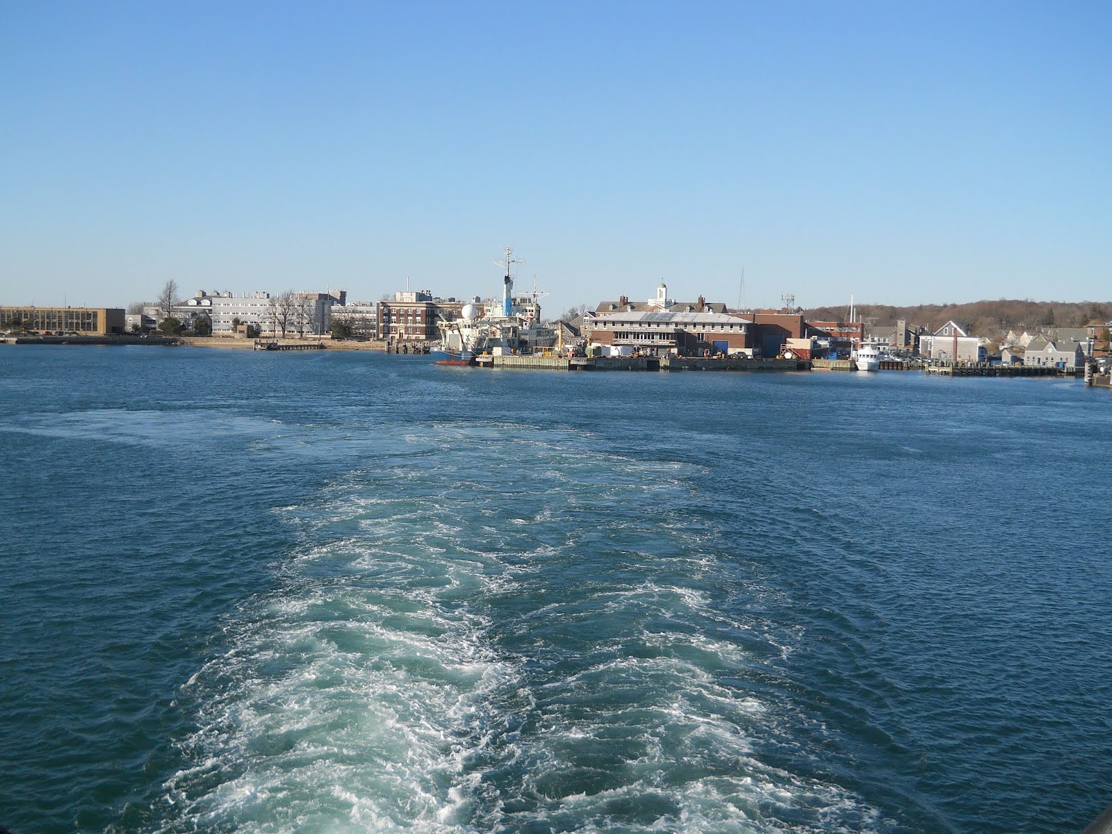
Despite EVERYTHING on the island being closed for the season, we still had a great time!! Jean had never been on such a large ferry, and we went from front to back taking pictures and looking out at the water the entire way there.


Once we landed, we took a bus to Edgartown, thinking we'd start with the one farthest away and work our way back to the ferry. The next bus would come at either 6:40 or 7:40 PM. Since it was already 6:30 PM, we had over an hour in Edgartown... We walked the wrong way despite carrying a map toward the lighthouse - the only thing we really wanted to see. Neither of us were paying attention, but once we hit the water where a lighthouse and city should have been, there was nothing more than sand and water and fancy houses. I was ready to turn around, when Jean suggested cutting through a field and then past the empty houses, through their backyards, and back to the street. We saw something that looked like a lighthouse, however, even after taking Jean's scenic route, we found that it was just a house mimicking a lighthouse. As luck would have it, an old man was walking down the street, so we asked him and he directed us to the lighthouse. :)


Edgartown was dead - that is putting it mildly. There was nothing open (not even the ice cream shop!), and not even much in the city to look at.


Despite the side trip, we still had about 30 minutes before the bus came. Of course another bus came, but I thought we still might want to go to Oak Bluffs and let it go. As we waited and it got dark and cold, I decided that probably wasn't the smartest decision I've made. LOL Oh well. Goodbye bus. All part of the adventure! :)

To pass time as we waiting for the bus (and to forget the cold), we took pictures. The picture of Jean with her feet in the air is by a really cool looking law office. The next is of me. Can you guess what I am posing as?


When the bus finally came, we were done. We skipped Oak Bluffs and headed straight back to Vineyard Haven, which is where the ferry is. Of course the ferry wouldn't leave for another 2 hours, but since we hadn't eaten yet, we decided to find a restaurant, have a couple of drinks, and relax in a warm place until we were ready to leave. Not going to happen... The place looked like a ghost town. Everything was empty. We did find a grocery store and stopped in. Then we asked for a restaurant and crossed our fingers as we headed toward a hotel restaurant. It was open!!! We went inside and saw the bar and wine and nice tables. Just enough time was spent getting excited before someone came to tell us they were already closed. :( Grrrr.... Well, there was ONE place open - the burrito place! They made HUGE burritos, but had no chairs or tables, so we each bought a large burrito and headed back to the ferry to eat and chat until the ferry was ready to leave. :)


At the ferry station, we met a young artist and photographer, and spent the time waiting, as well as on the ferry back, chatting with him. He met a girl and went to Martha's Vineyard to spend time with her. :) We told him about our journey as well. LOL Despite coffee to stay awake, I took a nap on the ferry. It was going to be a long 2 hour drive back to Rhode Island! (And since we met up there, we had 2 separate cars...) On the way, we talked about picking up saltwater taffy, and each time we looked (grocery store, etc) we couldn't find any. We did see some on the ferry, but by the time we remembered to buy it, we were in our cars on the way home. Par for the course.


We survived the adventure and had a great time together! But after the ride, we were both ready to curl up under warm covers and go to bed.

This was my favorite post. Haha. What an adventure.
ReplyDelete