


There were two national parks that I wanted to hit today. Canyonlands and Arches. Canyonlands is made up of 3 parts. The bottom part (closest to where I was coming from) is called the Needles. The scenery is not nearly as awesome as the northern part, but there are some good hikes there. The middle area is called the Maze, and you can't drive through there - just a lot of long hikes that people who are backpacking for long periods of time like to explore. And then there is the north part called Island in the Sky (which reminds me of the song "Lucy in the Sky with Diamonds" for some reason). This part of the park has some of the most incredible views in the country (in my humble opinion). I have been to the northern part of this park, as well as Arches previously, but this was my first time at Needles. I was hoping Annie would be able to come with me, but her work schedule didn't allow it.
Getting back to the drive... After the short drive to 211, which is the turnoff onto the road leading to the Needles at Canyonland, there were about another 35 miles to go. The scenery was beautiful and there were almost no other cars on the road except for the occasional early all day hikers and backpackers. There were also cows right up on the side of the road making sure you were paying attention to the road and not just the scenery.


The first hike I did in the Needles was a short one without elevation changes to Roadside Ruin. Following the theme of Mesa Verde, it passed by an Ancestral Pueblean granary (storage bin). There are several storage areas found in the Canyonlands, but very few actual dwellings. This could indicate that they farmed the land here, but only lived here seasonally.

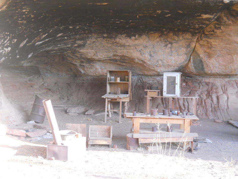
The Cave Spring trail was the next hike, which was a little bit longer, but more enjoyable. Unlike most hikes, there really wasn't anything at the end - the scenery and views were along the way. Hence the name, there were a number of 1/2 caves and overhangs to crawl and duck under, and then I climbed a couple of ladders onto some flat rocks to get a panoramic of the Needles area. This trail follows an area presumed to have been a campsite used by both Ancestral Pueblean Indians, as well as cowboys. The first alcove I passed was a bunk for cowboys and the second had pictographs, grinding sticks, and a smoke-blackened ceiling.


After the hike was a good view of the wooden shoe arch.

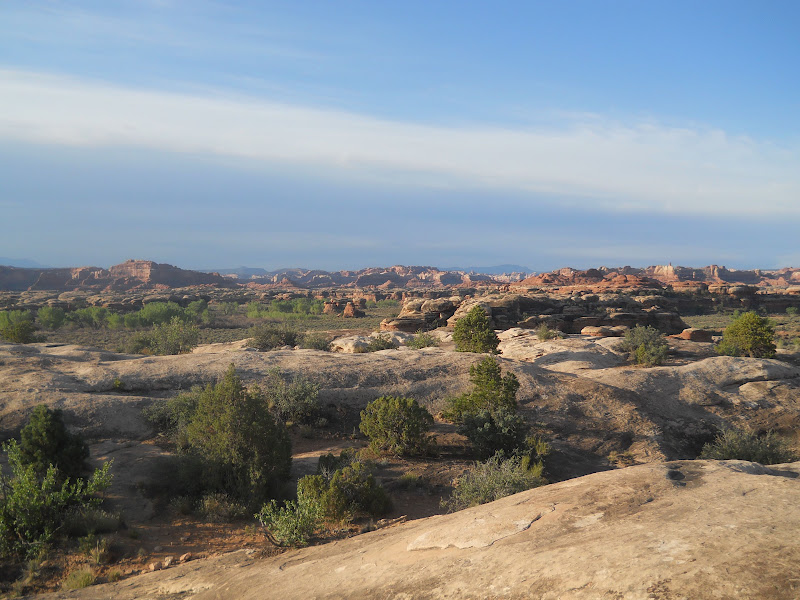
From there, you could see some great views of the "Needles", which are rock formations that have rows of needle-like pinnacles. The needle look was created from a series of fractures in the surface of the rock caused by movement along a deep, underlying, layer of salt. Basically, sandstone very slowly slid over this layer of salt toward the canyon by the Colorado River, and then the sandstone fractured into a bunch of parallel rows of canyons. Finally, rainwater and snow eroded the sandstone edges into the needle-like pinnacles. :-)

The road to Elephant Hill in the Needles is unpaved, windy, and quite bumpy. Some of you remember when I flipped my 350 Z off a small 7 foot cliff due to gravel catching in the wheels, so these types of roads - especially when there are dropoffs - give me a knot in my stomach as I peter up and down the small inclines at no more than 15 mph.
Elephant Hill is a place for those who love to hike. There are a few strenuous parts and most of the trails are 6-11 miles long, but they take you down to the more remote areas of the needles back country. Colorful rock spires surround a grassland at Chesler Park, which is only 6 miles round trip. On Joint Trail, the canyon walls narrow to just about shoulder width, and Druid Arch is the trail leading to a block of eroding sandstone.
Because I had much more to do today, I limited my hiking to about 3 miles in this area.


The last hike I did is called Pothole Point Trail, and rightfully so! The rock that occupies most of the trail is full of potholes!! (Even worse than Moon Rock!) This trail was a nice and easy 1 1/2 miles, though the cairns were sometimes scattered all over the place making it difficult to tell where the actual trail was.


After the hike, I drove the scenic road the rest of the way until it dead-ended. Out into the needles and beyond is the middle area of the park called the Maze. This is where I took a few more pictures and then turned around to have breakfast.


On the way I passed by the Wilson Arch, which is on the side of the road. You can see from the light how early it still is! :-)

Getting out of the Needles and through Moab took longer than expected. The city of Moab at 10:30 AM on Saturday was quite busy! There were people with 4-wheelers, bikers, hikers, motorcyclists, and college kids pulling open trailers with dirt bikes filling up with fuel, parked by coffee shops, and standing around waiting to meet others. There also happened to be a car show in Moab today, but surprisingly, I opted to go to the free national parks rather than the car show. However, that doesn't mean I didn't notice all of the Cobras, GT500s, and other fun autos while passing through. :-)
Shortly after coffee and breakfast, I made my way into the Arches National Park. Compared to the deserted Needles area, the Arches was packed! I guess people wanted to take advantage of the last 2 free days...
I believe I went trail crazy at the arches and went on just about every trail I could find. :-) The Park Avenue Trail was the first one. If you had someone pick you up at the other end, it's only an easy 1 mile hike. Without that, you have to come back, as well as climb back up the rocks. About 1/2 way into the canyon, you can see a number of rock formations, which make this trail quite enjoyable! The trail is called "Park Avenue" because the walls of the canyon reminded people of buildings lining a busy city street.


After the hike, I followed the park's main road up to the next trail. :-) Along the way I saw the La Sal white-capped mountains just past the desert. It is amazing to see the 2 extremes coexist.

There are several more formations that seem to crop up out of nothing - some are the formations that could be seen from the Park Avenue hike. These include the Courthouse Towers, Three Gossips, Tower of Babel, The Organ, Sheep Rock, Balanced Rock, Elephant Butte, and the North and South Windows.


The next several hikes are all about the arches. But how does an arch form? They start as small holes in rock faces, which over time continue to get larger and eventually collapse from weather and erosion. Water dissolves the calcium carbonate (which is like natural cement in the sandstone, and the sand grains are washed away. Arches then form, grow, and mature (just like us!) until they eventually fall away. In these 2 images you can see the possibility of a couple of arches that have long since fallen.


The desert area just past here is where the ancient sand dunes were. Over time, these sand dunes were covered with sediment that was compressed and cemented by quartz and calcite to turn into sandstone. Erosion has since washed away the layers, now exposing the "petrified" dunes.


Ah, another balanced rock. Seems to be one in every park. LOL Erosion helped create this as well. The balanced rock is sandstone propped up on top of a pedestal of mudstone. The softer mudstone weathers more quickly than the sandstone, which will make the balanced rock topple eventually.

A few more interesting formations along the way...


Then I passed by the Cove of Caves...

...and finally made it to the window arch formations.
For the curious few... Here is a little bit more information on the formation of arches. Entrada sandstone is the type of rock that forms arches. A series of uplifts and collapses cause severe cracking in the 300+ feet of Entrada sandstone.

When overlying rock layers erode away, the Entrada sandstone is exposed to weathering. Cracks widen and parallel rows of rock walls form.

Then, rainwater dissolves the natural cement (remember what that's called?), and combined with the pressure from water freezing in tiny cracks, causes the sandstone to crumble. Eventually, enough rock falls out to cause a hole. :-)

The holes continue to erode until they get so thin that the arch breaks.

Now getting back to the arches... There are 4 different arches at the Windows and a nice hike to reach them. I started on a trail to the right that led to the Turret Arch.


From there, I went through the arch and to the right toward the North Window.

Then I went to the South Window. Instead of coming back the same way, I decided to take the primitive trail back, which was longer, but more enjoyable with no tourists. You could see multiple arches at the same time. :-)


The trail also took me to the double arches.


Here is the Pothole Arch:

Panarama Point was a short drive to an overlook of Salt Valley rather than an individual arch. There was a group of bikers up there as well.


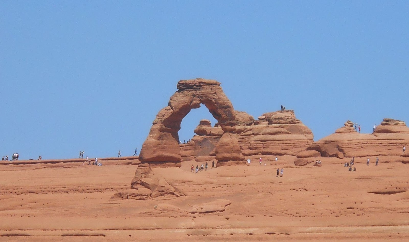
The next arch to hike to was Delicate Arch. Instead of walking under the arch, I opted to do the other trail, which was about 1.5 miles round trip up a moderately steep hill and rock, to get a good view of the arch. In addition to the arch, the trail provided a unique view of the park.


The next stop was to see the Fiery Furnace. Despite its name, it's not a hot place. It is named for the warm glow seen on the rocks in late afternoon, and is a bunch of cool, shady canyons between sandstone walls.


Time for more hiking!! The next 2 hikes totaled about 3 miles. Sand dune arch was much closer, but more difficult to walk through as it was thick sand that my feet sank into, making each step a challenge.


After that was the Broken Arch. There were a couple of pretty flowers that added color and life to the sand and desert greens. This was a neat arch to look at, and wasn't difficult at all to get to. There is no shade cover during the hike, so you could be in trouble if you fail to wear sunscreen!


Skyline Arch was the next arch I visited. This was a very easy 1/2 mile round trip hike, and the arch is a little bit different from the other slow forming arches. With this one, a large boulder suddenly fell out of the arch, quickly doubling the size of the opening.

Following this was the final trail called Devil's Garden, which had a number of arches along the way. I did not go all the way back to the Double O, but did see a few arches in about a 3 mile walk. The first was the Tunnel Arch.

And here is Pine Tree Arch. You can see how tall it is compared to me:


After the Arches National Park, I turned onto Hwy 313 and went to Dead Horse Point State Park. I believe these are the rocks that my buddy John base jumped from (one of many). There are a few trails throughout the park, but as it was already getting late in the day, I simply drove to the end of the road and walked along the edge of the beautiful canyon. You can see 2 man made lakes (very blue) and miles of natural canyons with the river weaving throughout at the bottom.
There were a lot of people at one area, and upon closer examination, I noticed they said a prayer and let cremated ashes fly through the air over the canyon. What an amazing way to go! It reminded me of when we let Dani go over the water at our annual rally a few years ago.


On the way out I stopped by their new cafe and had a sandwich. I had been hiking all morning and had little more than a breakfast burrito. The sandwich and a small bag of chips was $12, but I have to admit it was HUGE and overflowing with meat and veggies like a foot long sub. I ate in in the car on the way to the Island in the Sky section of the Canyonlands National Park. As with the lower part, the northern part also had cattle on the side of the road and great views of the canyons.


The first overlook is called Green River Overlook and is like a canyon within a canyon. I have to admit that I love the canyons through this northern part of the park almost as much as the Grand Canyon!!

The Aztec Butte trail was next, but it was closed at the bottom (don't ask why).

Then I saw Whale Rock. The last time I was here I climbed up it. I opted against the climb, probably since I was tired from all the previous hiking today, but still took a picture. :-)


I did, however, decide to hike up the Upheaval Dome trail, which wasn't too long. :-) Yes, I have been here before, but well worth it!! I used to think this dome was created by a volcano, but I was wrong. Some geologists think it was a meteorite, but most believe in the salt dome theory. (Didn't think you were going to learn anything, did you?) The Upheaval Dome is a 2 mile wide crater-like depression. Below it, there is a massive amount of salt that evaporated from ancient seas. Over the salt were hundreds of feet of sediments that later formed rock layers. The buried salt, which is like plastic under pressure, flowed upward, pushing the rocks upward to form a dome. Then, erosion stripped away the top of the dome exposing odd shaped rock that you see inside it today. Whatever happened, it's a pretty fascinating formation, and so different from most of the others!

The sun was starting to go down, leaving a shadow on the rock formations and a glow on the clouds.

I passed by Murphy's Trail, something I am reserving for Annie and Chris to hike. :-) The next one was the Buck Canyon Overlook. You can see why I compare it to the Grand Canyon.


Here is the White Rim Overlook:


And last but not least is the Grand View Overlook. Amazing!!! Pictures below don't do it justice.


When I left the park, the sun had dropped low in the sky and I drove to Torrey, UT to not only be close to the next park for tomorrow, but also to have dinner at Cafe Diablo - the place my sister told me is a gem.


The restaurant did not disappoint! I got there about 9:30 PM, but didn't feel rushed even though I'm sure they were going to close soon. They started me off with a nice glass of red wine and brought out a variety of veggies neatly organized on a plate with cheese sprinkled over the top that tasted phenomenal!

I was not too hungry after the late foot long sandwich, but tried their rattlesnake cakes. These tasted a little bit like crab cakes and with the different sauces that I sampled, was exquisite! Service was great as well (which I very rarely have a chance to say).

After dinner, it was almost 11 PM, so once again, I didn't have time to update the blog. The motel room was nice and warm, and within minutes (possibly seconds) I was out light a light.

No comments:
Post a Comment