
I also saw what looked like quail, and going over Hwy 62 (one of Oregon's scenic byways), I saw a family of deer on the side of the road. There was a beautiful bridge crossing over a lake and cliffs with tall pine trees. As I climbed up the winding road, it opened up to great views and tall rolling hills. There were also prairie dogs on the side of the road and winding creeks that moved with the highway. I tuned into a radio station that played old folk country music and it reminded me of Ralphie. :-)


My first stop was in Winston, OR, to the Wildlife Safari. The San Antonio Safari that I went on 2 years ago spoiled me. I was expecting all the wildlife to be on the road, coming up to my open window - the crazy ostrich to follow me, the zebra to stick his head in the car and onto my lap... But that was not to be at this safari!
I did see an ostrich, but he stayed off in the distance without the least bit of interest in my car. There were a LOT of cars on the dirt road, all going about 5 mph, stopping without warning, and not letting people pass. In some areas, there were about 4-5 cars all blocking the road for 5+ minutes as they enjoyed the animals without a thought to the cars behind them that were ready to move on. For someone who doesn't like waiting or moving slowly, this was just a little bit frustrating! However, I love animals, and used the extra time to watch the animals and take pictures. :-)
Here is the ostrich and the zebra.


Then there were turkeys mixed in with lions...


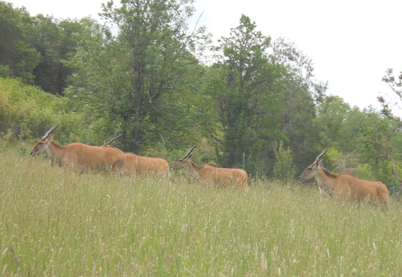
And then you have a hippo and antelope.

The giraffes were being led by a couple of vehicles up the road and over to their gated area.


Although not rare - especially living in WI - I still enjoyed seeing the family of ducks and the geese.


Next, I drove past a herd of buffalo and came upon a couple of sweet looking black bears.


On the other side of the safari park, I drove by a buck, female deer, elk, and big horn sheep.


The llamas were cool, except for the shot of one bending over. LOL


I saw many of the same animals coming back on the other side of the park (it's a loop). Here are some of my favorite shots. Note that the giraffe is now back in its cage!

The rhinoceros is new!


Check out those horns!


There was a monkey playing in his jungle gym.


There was also another section that had cheetahs and tigers. Cheetahs are the fastest animals on the planet, going as fast as 70 mph!! (Dad, does your Geo even go that fast?) :-D


I left the safari park in a great mood, and headed up the coast beginning in Coos County. For those of you who don't know, Oregon has an even more amazing coastline than CA (in my opinion).
I heard sirens every few minutes in Coos Bay, and after seeing about 15 police cars pass me by in a 5 minute period, I wonder what was going on. There was a road blocked off up ahead with police cars on the sides, but I didn't see a large number of cop cars there. It might have been on the news that night, but I didn't watch it.
North of Coos Bay were the sand dunes. I took a nice hike through the John Dellenback Dunes, which is an easy 1 mile hike each way to the sand dunes, and then you can walk up and down the dunes as much as you'd like.


I had a blast walking up the sand dunes as you can see so far from the top!!!! The sand dunes were not too hard to walk on, and they looked beautiful!


There were a few wooden historic bridges, like this one, crossing over the Umpqua River.


There were more sand dunes down the ocean along the coast, and then continuing north, the road climbed to some beautiful overlooks.


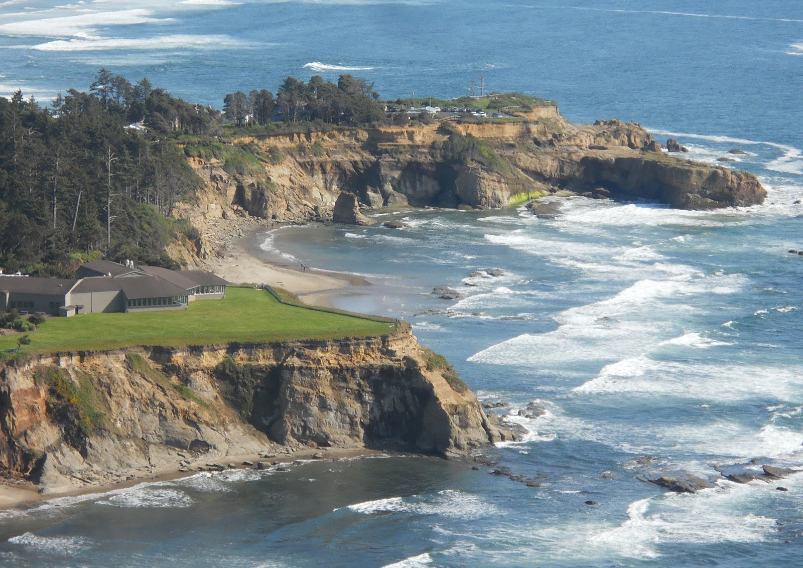
North of Florence I stopped at the Sea Lion Cave, which boosts being the world's largest sea cave. You couldn't actually go over by the sea lions as you were separated by glass, but there were plenty of opportunities to look at all of them from being down inside the cave or from the overlooks above the cave.


Going down into the cave, the floors are in feet, so we get off at 200 (200 ft under ground). It looks pretty cool to see an elevator with a floor "200"!!! :-)

The cave was decorated as a tourist spot rather than a natural cave (at least in the areas I could walk), but the walls and ceiling were made up of the rock in the cave.

The Stellar Sea Lions land in the cave during the fall and winter stormy season, and on the rock ledges outside during spring and summer. Sea lions average living 20 years. The bulls keep 10-20 cows during breeding season, which is every other year. Bulls average 1200-1500 lbs and cows weigh 500-700 lbs. Pups are born at about 40-50 lbs. (And we complain about having a 9-10 lb baby!)


The black birds you see on the cliffs below are called Cormorants.


I got a picture of me by the fake sea lions. You can see how windy it was out! :-)

I left there and continued heading up the Oregon coast.


I crossed over Cook's Chasm Bridge. It's interesting to note that before all of these bridges were built, the Oregon coast would have been very challenging to cross! There are a lot of beautiful rivers, chasms, and inlets, but the bridges allow us to seamlessly drive along the coast while enjoying all of the natural beauty. The original bridge over Cook's Chasm was built in 1932, bur after 70+ years of salt, wind, water, and corrosion, it needed to be replaced.


Under the bridge in Cook's Chasm, is spouting horn. Pounding waves over time gradually fractured the rocks, creating a cave. There's a hole in the roof of the cave. During high tide and storms, strong waves funnel water and air into the cave, building up pressure, until like a geyser the water explodes up through the hole in the roof. There was no geyser like activity today...


This is what it would look like if it exploded:

I did get to see some pretty amazing smashing and crashing of the waves though! There's an area just a short way up called "Devils Churn". The waves explode in white waves and froth crashing up against the rocks angrily. What used to be a small crack has turned into a chasm of volcanic rock from all the waves crashing against it.


I was careful not to get too close, but walked far enough onto the rocks to get a close up of some of the waves crashing up agaisnt the rocks. Very powerful!!


From there, I went through the small town of Alsea and crossed the Alsea Bay Bridge. It was interesting to see all of the tsunami warning signs in the low areas (at sea level) along the coast. I don't recall ever seeing them in CA or FL, but they were everywhere in OR...


More gorgeous scenery...


Then I came upon Cape Foulweather. It was named this because when it was discovered in 1778 by Captain James Cook, the weather was very stormy with winds around 100 mph.


I mentioned the tsunami signs before... During the 18th century, the OR coast was full of Native American villages. For instance, you have the Indians who lived on the Yaquina River and flattened their heads in childhood to distinguish themselves from other tribes. Well, in January 1700, Siletz Bay and other nearby beaches were hit by a devastating tsunami. There was a 9+ earthquake that happened along the offshore coast fault (the Cascadia Subduction Zone). From Northern CA all the way to British Columbia along this fault line, the ocean floor rose by 20 feet from this huge earthquake. Within minutes, a 50+ ft wave was hurling toward the shore. For hours, devastating waves battered the shore, flooding beaches, bays, marshes, and tidal channels, wiping out many of the Indians who lived down by the shore. Other tribes had documented the great shaking of the earth and flooding, which coincides with this tsunami. Apparently, they happen every 200-1000 years, but obviously not during the time I was there!


By the time I arrived in Lincoln City, it was time for dinner. I found a motel for the night, and on the recommendation of the young man working at the motel, I had dinner at Mo's. My table had a beautiful view of the ocean, and following dinner, I took a walk on the beach to enjoy sunset.


As the sun went down through different cloud layers, it painted the sky all sorts of shades of orange, with light pinks and purples in the background.


On the way back to my car, I saw people sitting around campfires made on the beach. There was also a guy who looked like he was fishing. Since it was late, I went over to see what he was up to. He was trying to catch crabs (no, not THAT kind), but they were all too small. I thought they looked perfect, but he had to put them back.


No comments:
Post a Comment