
Instead of just driving from Mount Rainier to Olympic Nat'l Park, I decided to head west to Astoria (which is back in Oregon), and then take the scenic 101 by the coast up to the park from there. I left very early in the morning since the park covers a lot of ground.

To get to the tower in Astoria, which is supposed to have INCREDIBLE views of the city and ocean, I had to climb up several very steep roads with my Focus. As can be expected in Washington, the sky was nothing but fog and light rain. I knew I would not be able to see much, but I thought it might open up at least a little bit. Wrong! As you can see from the tower, there was nothing but fog in all directions. :-(


Oh well. I still had a full day in front of me. I crossed the Astoria-Megler Bridge, which is quite long, and headed north on 101 toward the southwest entrance of the park. You can see from these pictures that the weather was not going to cooperate...


Olympic Nat'l Park is surrounded by national forest land, which is not part of the park. However, there were still a few places I pulled off based on my research.
I read that the loop around the Lake Quinault Rain Forest was very scenic. I started from the south (South Shore Road) and stopped after about 10 miles, turning around rather than completing the loop. It was not that great, especially given the poor weather. While there, I did pull off and took a hike through the rain forest, which I thought was very appropriate as it was raining. :-)


You can see giant trees, like the Douglas-fir and Spruce, along the way.

The Olympic Rain Forest is a temperate rain forest (not a tropical rain forest like the ones in South America, Congo River Basin, Madagascar, or the ones we saw in the Milwaukee domes). Temperate rain forests get more than 100 inches of rain annually. They have a mild, moist climate (thanks in part to their location near the ocean). They are a multi-layered forest growing mostly needle-leaf trees. Thanks to the moisture and rainfall, these forests are full of lichens, mosses, fungi, and epiphytes. They also have a lot of standing and fallen dead trees.
In comparison, tropical rain forests are located near the equator (mostly between the Tropic of Cancer and Tropic of Capricorn). The higher temperatures cause quicker evaporation, resulting in more rainfall.


After hiking through the rain forest, I continued along the scenic drive by Lake Quinault. It looked almost spooky with the fog, and I half expected to see alligators or crocodiles floating by...

From here, I returned to Hwy 101 and continued heading north. Before I continue, I would just like to point out that this was probably my least favorite park, and not one I would recommend to people. To give you an idea why, the park is made up of a number of long branches (15-30 miles long) with no outlets that extend inward from Hwy 101. In order to reach these branches, you drive around the 101, which starts at the southwest side of the park, goes up to the northern tip of Washington, and then heads east past Port Angeles, forming an upside-down U shape, coming down south on the east side of the park by the water near Seattle. (The entire park is on the northwest peninsula of Washington.)
The drive along the 101 is 45-55 mph in most places, dropping down to 25-35 in other spots, and consists of about 215 miles around. In the rain, at slow speeds, with traffic, it will take at least 1/2 a day just to drive that! You can't see anything special on Hwy 101. Therefore, you have to drive the extra 15-30 miles (each way) inside the park to reach most of the interesting things... It ends up being almost 400 miles of driving!!!! If you add in the hikes and everything else, you need multiple days. I don't mind spending more than one day in a park, but to drive 60 miles on top of the already long drive to do a 1 mile hike just wasn't worth it. (There wasn't that much to see/do at the end of each "branch", which can take 30-50 minutes to reach. Despite all of the driving, the park does have some pretty neat things that I tried to capture in the photos...
The 101 moves northwest until it reaches the ocean. From there, there are several beaches up the coast. I stopped at Ruby Beach. The rain slowed to a drizzle, but the sun refused to show itself. The beaches have riptides (strong currents) and drift logs (dead trees on the beach from the forest) that can both be dangerous, particularly at high tide. The north Pacific shoreline (as was seen up the Oregon coast) is also a tsunami zone as it's right off of the fault line.


There were some pretty interesting rock formations along the beach, and with the fog, it looked like part of the Goonie's movie.


From the beach, I continued along 101 and took the turnoff to the right for the Hoh Rain Forest. This was a long, winding road at a posted speed of 35 mph for the next 25-30 miles. The trees were different than the last rain forest. Most were Sitka Spruce and they had moss on them and seemed to lean in toward the road, making them appear thicker in cover than they actually were, as they were still fairly bare. The fog was still thick here, giving it an eery feel.


Here was an example of a large spruce tree.

Once I got to the parking lot, I went on the loop trail called "Hall of Mosses". There was also a spruce tree trail, but since I would be seeing a lot of tall spruce trees on the drive and on the hall of mosses trail, I opted to only do this one. It was worth it! This was a short trail, about 1.5 miles around.
Like dominoes, when a large tree falls, it often takes down others with it that are in its path. The trees are very tall but have very short roots. This is because they don't need them to collect moisture as there is plenty in the ground. However, this also means they fall much easier in winter storms as there is nothing securing them to the ground.

The moss on this trail grew everywhere - tree trunks, leaves, dead logs, you name it. It was very thick in most places and completely covered the forest like dust webs in an attic.


The most common was the licorice fern and clubmoss. Both of these plants dine on the moisture and nutrients in the air (from rain and windborne particles). They fasten to trunks and tree branches, but don't injure their hosts - the trees.


Here is the maple grove. It looked like something out of a Dr. Seuss book.


These bigleaf maples support denser clusters of airplants and epiphytes (the lichens and hanging mosses).


This is what's called a nurse log. Hemlock and spruce seedlings, unable to survive on the tangled forest floor, absorb minerals, moisture and warmth from the decaying trunk. Even on this "perch", competition is fierce! Only a few seedlings last. After their roots reach soil, new trees often seem to stand on stilts as the nurselog crumbles away.


I returned to the 101 and continued heading north until I saw the left turnoff for Realto Beach. There was a river flanking the road. Across the river is the Quileute Indian village of La Push. James Island was their fortress during raids from neighboring tribes. For thousands of years, salmon runs and the migration paths of seals and whales linked the Quileute to La Push.


Also on the way to Realto Beach, I decided to drive a bit too aggressively for the local park rangers. The speed limit was 25 and I was going about 45-50 without realizing it. There was no one on the road, and when I did see a car or felt I was driving too fast, I slowed down a little bit. However, a ranger coming the other direction obviously noticed my speed and quickly turned around. I continued along and drove to the parking lot when he stopped by my car and had a few words with me about slowing down... I promised to behave and abide by the speed limit signs from this point forward. :-)
Realto Beach is full of small stones and sand that sink in when you walk.

It makes it difficult to walk and hurts my calves as it's a lot of effort for each step. However, the 3 mile round trip to the hole-in-the-wall was well worth it!!


About 1/2 way through, I had to either wade across a stream or cross over some fallen logs. I chose the logs. More fun. :-)


This also reminded me of the beach from the Goonie's movie and you'll see why, with all the rocks protruding from the water and the fog creeping in.


This rock had a tree on top of it!

I reached a series of rocks and noticed a family looking intently at the ground, so I walked over to see what they were looking at. There were barnacles, sea anemones, starfish, shellfish, and much more!


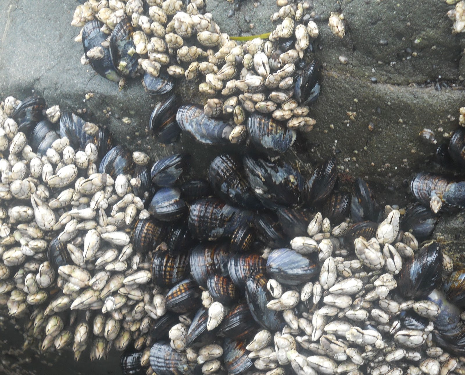


I could see hole-in-the-wall from here! So the family and I walked over there together. It was slippery and you really had to watch your step to avoid tripping, but more importantly, to avoid stepping on the many living things that made their home in the rocks.


These were 2 of my new friends and fellow explorers who helped me find all of these sea animals and plants. :-)


This hike was the highlight of the day and the best part of the trip, though the Hall of the Mosses hike was something I'm glad I didn't miss either!
From Realto Beach, I hopped back on my now favorite road (the 101), which went north and then curved around to the east where Washington basically meets Canada on the other side of the water. After about 50 miles or more, I made it to the scenic Sol Duc "branch" and headed south on that.
The Sol Duc River is up at 5,000 ft. A trickle of mountain water feeds tiny rivulets that merge into streams. As the route steepens, water plunges down hanging paths carved by the Ice Age glaciers.

Much more scenic than the Sol Duc River was Lake Crescent. There was a bad accident down on the far end of the lake, where a semi fell over on its side, probably to avoid hitting a car? Either way, it made me more aware of my speeds and if memory serves, it slowed me down a bit...


You can see how low over the water the clouds are.

A little ways past the lake and before Port Angeles I came to Elwha, which is another scenic road. On that road I hiked the Madison Falls trailhead, which wasn't far.

When I reached Port Angeles, I could continue down 101, which went north and then continued east through the city. That is where the ferry to British Columbia, Canada is. I chose to get off on the side road that went to Hurricane Ridge. This road was supposed to have some really beautiful overlooks and neat trails. I started along the road, which was clear for the first 1/2 mile.

Then, I was climbing along the edge of the cliff in complete fog. There were 3 tunnels to go through as well, and these were all pitch dark with the fog on either side, even with my lights on. I continued to climb in the fog for a few miles, but eventually I gave up and turned around. I wasn't going to hike or see anything through the thick clouds. It did bother me that I went through the "pay station", showed them my annual park pass (or it would have cost $15), and they didn't bother to say anything about the no visibility. If I had to pay for that, I'd come back down asking for my money back. Just an observation...


Even without traffic, it would take me about an hour to reach the ferry. Taking the ferry from Bainbridge Island would save me about 100 miles of driving to Seattle. I had picked up the schedule and a map from the first Visitor Center I came across and now looked at the time. The next ferry was leaving in 30 minutes, and the following one in 90 minutes. I was lucky to make that one! Traffic picked up on the 101 from the east side by the Hood Canal. It was mostly a non-passing 2 lane road, with the cars in front going about 20 under the speed limit (my punishment for speeding earlier I think). Despite that, I reached the island with 15 minutes to spare, bought a ticket, and waited in line. After about 10 minutes I was able to board. My car was sooooo excited!!!! This was the first time she was on a boat, so I gave her a window view. :-)


The ferry was huge!

That was Bainbridge Island.

And this is Seattle.

Here is a view from my car's window.

The ferry ride was only 30 minutes long and by 7 PM we reached the dock in Seattle.

It took another 10 minutes to tie up the boat and unload, but overall, the entire trip went by very quickly. My first stop was by the Hammer Man. This is a moving metal structure by the museum of a very tall man swinging a hammer up and down.


Established in 1971 and still going strong today, this is the site of the very first Starbucks!

Probably the coolest thing to see (other than the capital building which I didn't drive to) was the Space Needle, where you pay to climb to the top and look out. Unlike the fog by Olympic Nat'l Park, the clouds seemed to be taller than the building and not obstructing the view of the city, so I went to the top. These are 360 degree views of Seattle, including a close up of a co-ed flag football game going on somewhere down below. :-)


I thought about eating dinner in downtown Seattle, but since it was already getting pretty late and I wanted to see the Fremont troll, I opted against that and went from here straight to Fremont. I was also going to go to see Bill Gate's house, but it didn't interest me as much as the troll (priorities), so I skipped Medina.
In Fremont, I went over the Aurora Bridge and parked. There was a beautiful and very long mural painted under both sides of the bridge.


Under the bottom part of the Aurora Bridge is the famous troll. You can see how large it is by the kids climbing all over it. :-)


Here is a statue of Lenin.

I had to make a stop to the Center of the Universe, of course, and look at the guidepost.

It was close to 9 PM by the time I left Fremont, so I headed down the freeway to find a place to crash for the night.

MJ - Astoria is where Goonies was filmed!
ReplyDelete