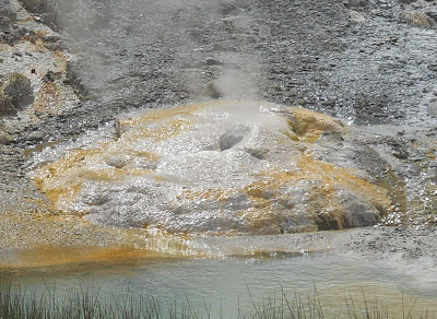
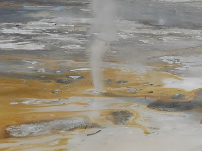
In this Basin, water accumulates underground. Heated by the Yellowstone Volcano, the water travels upward to erupt from acidic geysers, rise from steaming fumeroles, and simmer in shimmering pools. (It sort of reminds me of the way the unstable asteroid was portrayed in "Armageddon", only adding the sulfur smell and a few trees to it.)
On this trail, there is the Back Basin Loop (which is actually divided into 2 parts) and the Porcelain Basin Loop (the shorter one). It goes through some forest area, where I saw claw marks in trees that had bark scraped off. I wonder if grizzlies frequent this area. Hmmm....
I did the Back Basin Loop first, which is 1.5 miles around and then finished with Porcelain Basin Loop.
Blue Mud Steam Vent:
Pearl Geyser:
Monarch Geyser Crater:
Minute Geyser's eruptions have changed dramatically. The large west vent is clogged with rocks that people threw in when the park's main road was within 70 feet of this geyser. It used to erupt every 60 seconds to 40-50 ft, but they are now irregular and originate from the smaller east vent.
This is Emerald Spring. A hot spring's color often indicates the presence of minerals. In a clear blue pond the water absorbs all the colors of sunlight except blue. This is a 27 ft deep pool lined with yellow sulfur deposits. The yellow color combines with the reflected blue light to make it appear an emerald green color.
Here is a fumarole. I saw a few of these before as well. These are the hottest of Yellowstone's geothermal features and are steam vents. They can get up to 280 F, so don't get your face near one!!
Interesting patterns.
Does anyone remember what temperature green represents??? ;-)
This ground and scenery was like being on a whole different planet. I cannot imagine running into this as I walked or rode horses across the states many years ago!
This beautiful area behind me is called the Porcelain Basin.
Little steam pockets are everywhere!
This picture looks so out of place compared to the thermal ground and steam everywhere, but it was taken from the trail!
When Steamboat Geyser erupts, it shoots scalding water 2-3 times higher than Old Faithful into the air. Eruptions are 4 days to 50 years apart from each other, so very few people actually get to witness it.
Yes, Cistern Spring is HOT!
Here is Echinus Geyser. Millions of spine-shaped deposits surround this geyser. Iron, arsenic, manganese, and aluminum are all found in the acidic fountain of water that showers the landscape.
Crater Springs:
With still a few hours left in the day, the sky was not looking too promising! Luckily, I avoided a storm. :-)
This is Arch Steam Vent:
After Norris, I was going to head north to Mammoth Hot Springs, first taking a short side trip east of Norris to drive along the Virginia Cascade road. I was not impressed with this waterfall after seeing so many others, but if you like waterfalls and have the time, go for it.
It is 21 miles from there to Mammoth Hot Springs. Along the way (and thanks to people pulled over with hard core binoculars) I saw a gray wolf and female moose. They were too far away to show up on camera (though I still tried), but it was fun to watch them through a lens. I did get the mountain goat though! :-) Here are some photos of this 21 miles of Yellowstone...
Yellowstone Plateau glowed red from volcanic activity, with molten rock welling up and spreading from numerous fissures. This is Obsidian Cliff, which is molten glass. It's part of 180,000 yr old lava flow. Cooling and shrinking, the lava solidified into large columns (visible at the base of the cliff). Because people keep removing pieces of obsidian as "souvenirs", the cliff is losing its shine.
This reminds me of the Devil's Postpile in Mammoth Lakes, CA. It is called "Sheepeater Cliff", named for the Shoshone Indians who lived throughout the mountain region and their use of bighorn sheep. The cliff is basalt lava that formed "columnar joints" when it cooled nearly 500,000 years ago.
The mountains in the background are the Gallatin Range, to the north of Yellowstone Park.
It was a pretty drive and there were cascades along the side of the road as well.
The cliffs on the sides here are called "Golden Gate". To reach the Yellowstone Plateau from Mammoth Hot Springs, a wooden trestle had to be built by engineers in the late 1800s along the sheer wall of light-colored volcanic rock (hence the name "Golden Gate".
"So steep is the climb that if the tailboard of a wagon falls out...the whole load is promptly dumped out in the road."
This is very zoomed in, but it's my very own "Billy Goat Gruff" by the Golden Gate cliffs. :-)
This is the result of a fire in 1988 that destroyed several areas of the park. There is a lot of regrowth occurring.
Bison were everywhere. If you saw nothing else, at least you were guaranteed to see buffalo (and elk).
There are 2 moose in this picture. Can you find them? Hint: they are on the grass just in front of a pine tree to the left of the tall dead tree and to the right of the large log. (Sorry, kind of far away to see well.)
This is Nymph Lake.
And this is Roaring Mountain (though I did not find this overly impressive).
There is a really awesome hike that goes around the top Mammoth Hot Spring Terrace and down to the bottom, and then back up again. It could be done as a loop or just doing the top part and then driving down to the bottom part. The scenery on this loop was more impressive to me than just about anything else. It was like being on a different planet, but still very different from the "asteroid" scenery. You'll see what I mean in the pictures...
Summertime "snow" :-)
This looks like an ice or snow field, but it's just the dried ash from the volcano!
The thermal areas make fascinating designs!
There were a few formations that I passed on the way down to Fort Yellowstone. This is Orange Spring Mound. Hot water flows over the mound after bubbling through several vents along the top. Above ground, the water begins to cool and evaporate. Gasses are released and water pressure decreases. The mound gradually grows as water flows over it, depositing calcium carbonate.
There was a family of elk with antlers just starting to grow on the males.
Down below, you can see the city of Mammoth Hot Springs and old Fort Yellowstone.
At the bottom of Mammoth Hot Springs is Liberty Cap - a dormant hot spring cone.
Here is a picture of Fort Yellowstone.
Cavalry and stagecoaches stirred up dust clouds on the streets of Mammoth Hot Springs. From 1886, the US Army was responsible for protecting Yellowstone and most tourists used to use the North Entrance. The buildings below were officer's quarters, a guardhouse, cavalrymen's barracks, stables, and a chapel. In 1915, autos were allowed in the park and horses were banned the following year.
It was starting to rain, so even though it was only about 8 PM (with 1 hr of sunlight left), I decided to stop in Gardiner for dinner and a night in a motel before spending another full day in Yellowstone. Deer and elk were everywhere and you really had to be careful not to hit them with your car!
The weather wasn't great, but at least it was the end of the day! I had no complaints about the weather during the day other than a few light sprinkles.
Dinner was at the Cowboy's Lodge and Grill. That's my silver Focus with a great parking spot! LOL


No comments:
Post a Comment